This Map Shows The Creepy Satellites Passing Above Your Home In Real Time
Artist and engineer Patricio Gonzalez has used the available open
resources and metadata to create a real-time interactive map for
satellite watching. His creation, Line of Sight, is an amazing map that
shows the satellites over your city in real-time.
Do
you know how many satellites are orbiting the Earth right now? Well,
the exact number would be something between 2,250 and 2,3oo. These
satellites move around the Earth at about 17,000 miles per hour. That’s
an incredible speed and they can cover a very large distance in just
a few minutes.But, these few minutes are enough to locate them
if you know the right method and resources. Patricio Gonzalez is an
artist and an engineer at the open-source mapping startup Mapzen. He has
created Line of Sight, an amazing map that shown the satellites over
your city in real-time.
You can head over to this link, enter your city’s name, and hover to see which satellites are over your city.
This map has been created using the available metadata from sources like SatNOGS. Gonzalez’s creation uses them to track the satellites and presents them right in front of you.
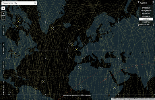
Satellite watching isn’t something new, but Gonzalez has made this very fascinating and easy with Line of Sight.
This map has been created using the available metadata from sources like SatNOGS. Gonzalez’s creation uses them to track the satellites and presents them right in front of you.
Satellite watching isn’t something new, but Gonzalez has made this very fascinating and easy with Line of Sight.

Comments
Post a Comment